Sunday, December 16, 2007
Mom's travels
Mom's going to be in India for three weeks, and she's started a blog to tell you about it.
Wednesday, December 12, 2007
DQed
The sunlight came through the window and hit the little statue of Don Quixote that I keep on the bookshelf in what struck me as an interesting way today, so, for no particular reason:


Sunday, December 09, 2007
Compost bin
 I intend for this space to be non-political, but some of our environmental commitments are hard to avoid. And there shouldn't be anything controvertial about not taking risks with our future. So while I'm distressed by how little I can do, it does please me to take a few steps in the right direction whenever possible. In that spirit, Nicole and I recently purchased a compost bin for our condo association - pictured here under a pleasant pile of recent snow. Chicago, which has a long way to go before it deserves its green reputation, also seems to be taking little steps that make me feel better about living here as the months pass. For one, they offered these compost bins (and rainwater barrels, which we couldn't use) at highly subsidized prices at their Center for Green Technology. (See also this article about our alleys.) Composting our kitchen waste seems to reduce our personal trash by 40-50%. When spring arrives, the pile of leaves and scraps will decompose quickly, and we'll be able to use it to improve the soil in our common backyard.
Sunday, October 28, 2007
Indiana Dunes
We went to the Indiana Dunes today to enjoy the sunny fall weather and the last days of seasonal color. Even the ferns were getting into the act:

The forest was mostly quiet; we saw very few birds. But for whatever reason there were ladybugs everywhere at the beach. I was looking poking around in the dune grasses and found these. The dark blue in the background is Lake Michigan.

Saturday, October 27, 2007
Mexico, 1950
Here are some of the pictures that Simeon Leland (see posts below) took of Mexico in 1950:

I've showed some of the photos of more rural areas to people who have traveled throughout Mexico more than I have, and they suggest that, based on the clothing that people are wearing, they were probably taken in Oaxaca or Chiapas. This guy, judging by his pants, has been to Los Angeles or thereabouts.
The Zocalo, Mexico's main square:
Below you can see what the same space looks like in 2007. Fewer trees, no cars, more people, a metro stop that you can't see. Another thing that you can't see: the Templo Mayor of the Mexica / Aztecs, which was thought to be lost but in fact is right next to this cathedral. It wasn't found until the late 1970s, so although you can't see it in either photo, it wouldn't have been there at all in 1950.


I've showed some of the photos of more rural areas to people who have traveled throughout Mexico more than I have, and they suggest that, based on the clothing that people are wearing, they were probably taken in Oaxaca or Chiapas. This guy, judging by his pants, has been to Los Angeles or thereabouts.

The Zocalo, Mexico's main square:

Below you can see what the same space looks like in 2007. Fewer trees, no cars, more people, a metro stop that you can't see. Another thing that you can't see: the Templo Mayor of the Mexica / Aztecs, which was thought to be lost but in fact is right next to this cathedral. It wasn't found until the late 1970s, so although you can't see it in either photo, it wouldn't have been there at all in 1950.

Monday, October 01, 2007
Comparing Buenos Aires
Here's are comparison photos from me in 2006 and Simeon E. Leland in 1950 (see post below) of the "obelisk" in Buenos Aires.
1950:

2006:

And here's one that Nicole took that lets you see the considerable increase in the use of fluorescent signs:

1950:

2006:

And here's one that Nicole took that lets you see the considerable increase in the use of fluorescent signs:

Friday, September 14, 2007
Fifty-six years later
I think I've mentioned here in the past that my great grandfather, Simeon Leland, was once the chair of the department of economics here at the University of Chicago. He was also something of an amateur photographer. It turns out that he took some kind of official trip to Latin America in 1950, and Dad's visit here meant that I had the chance to digitalize some of the slides that he took at that time. He and I have been to some of the same places, and so you can compare rather directly how things have changes over fifty-odd years. I have slides from Argentina, Chile, Peru, and Mexico. I'm not going to post them all at once...but here's one from Chile's major port, Valparaiso, where we had almost the exact vantage.
As you can see, in 1950 it was already quite a busy port:
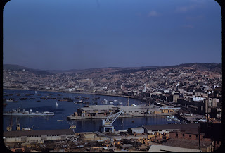
Here it is in 2006. If you look at the photos at full size it's easier to see how much more closely packed the hills are.

As you can see, in 1950 it was already quite a busy port:

Here it is in 2006. If you look at the photos at full size it's easier to see how much more closely packed the hills are.

Tuesday, September 11, 2007
New Floor
I'm back in Chicago, and Dad has been visiting here the last week. Our major project has been to re-do the floor in the pantry. The previous owners of the condo had done a beautiful job doing the bathroom and the kitchen, but the pantry remained undone. When we were preparing the floor, we found two things: under the linoleum, a penny from 1953 and a scrap of newspapers from 1925. The 1925 paper probably dates the layer of tarpaper, directly above the wooden flooring; the penny probably dates the linoleum. At any rate, here is how it used to look:

Since we didn't want to pull up the old linoleum, but needed to even out the floor, we put down a layer of cementboard. The old baseboards seemed moldy, so we pulled those off as well:

On top of this layer, we put down the tile. When we went to the store to get new tiles, we didn't find a sufficient number of the red ones that we liked, so we put some white ones in the middle. I'm glad it worked out that way, since I think this looks even better that it would have with all of the light-red tiles. After putting down the cement mastic, we added the grout and the new and newly-stained baseboards. Now it looks like a real pantry! Thanks for all the help, Dad.

Wednesday, August 22, 2007
Hurricane Dean
Well, Hurricane Dean hit the Yucatan, went across the gulf, and has now hit central Mexico. According to the link there, the eye of the hurricane passed within 95 miles of Mexico City. Thus it has been raining here all day, though there have been no high winds. It feels strange - during the summer here it rains every afternoon. But it started to rain at four in the morning, and hasn't stopped since. I went to the National Library anyway, which is down on the enormous campus of the main public university of Mexico, the UNAM, which has almost 300,000 students. Next to the library is a something like an ecological reserve, with a number of beautiful sculptures. Here's a picture of one of the flowers there (which actually do a remarkably job of matching the sculptures around them), with the library in the background.
 Everything should be normal by the time I leave on Friday.
 Everything should be normal by the time I leave on Friday.
Saturday, August 11, 2007
Mexico City and the Environment
Mexico City has a reputation as an environmental catastrophe, and to a certain extent, this is obviously true. The problem du jour seems to be that overuse of water is leading to a rapid depletion of the aquifer below the city, leading to rapid settling and sinking. Many of the old colonial buildings found in the city center, not to mention the pre-Hispanic buildings, are tilted and sunk. But apparently large parts of the eastern half of the city could sink and flood in sewage water following just the right kind of rain.

On the other hand, there have been a few areas of serious progress. In addition to an extraordinary metro system, with 11 lines, Mexico City built a "metrobus" line a few years ago. It took a major street (Insurgentes) and prohibited any small street buses from operating there. Removing all of these old buses greatly reduced emissions in the area of that street, and they were replaced with a very smart system. The median of the street has been converted into a series of shelters and the adjoining lanes have been made into bus-only lanes. The metrobuses run up and down those lanes, so they don't have to worry about traffic, creating an additional advantage to the bus by making it relatively more attractive when compared to driving. Another benefit is that emergency vehicles can use the lanes to get down the street quickly. The biggest problem is that there aren't enough buses to handle the number of people who want the service, which makes them packed at almost any time of day. The city is considering many more lines like this, which are obviously much cheaper to create than an actual metro. It is an idea that I'd like to see copied in American cities. One might object that this will create more traffic problems, and this might be true. In a US city there won't be reduced levels of traffic because of pulling lots of little buses off the street. But still: the people on the buses won't be stuck in traffic, and so more people will use the bus, pulling cars off the street and hopefully reducing emissions.
The other thing to notice is Xochimilco, at the end of the city, which used to be the site of watery gardens that fed the Mexica empire. Today this area is the only part of the greater city area that retains the aquatic character the city would have had 500 years ago - there are boatmen and canals here like Venice. Twenty years ago the land was a polluted, swampy mess, but some treatment plants were built and whole areas were replanted. Although people still feed the ducks far too much, the environmental health of this area has clearly improved. Small reasons for hope.

Monday, July 30, 2007
Teotihuacan
OK, so you're in Mexico City, you're obligated to go see Teotihuacan. Much of it was constructed between 100 and 650 AD, thus predating the more famous civilizations that the Spanish encountered. Teotihuacan, in fact, was a ruin when the Mexica (Aztecs) were the dominant empire.

I stitched together this panorama from a few shots. It's taken from the second largest pyramid on these grounds, known as the "Pyramid of the Moon." On the left side of this main footpath is the third-largest pyramid in the world, known as the "Pyramid of the Sun." (Those at Cheops and Cholula are bigger.) Still, it weighs more than three million tons, and was constructed without the wheel or animal labor. This means that if there were a million people working on the structure, they would each have to move 6,000 pounds of rubble. Yet the population of this town peaked at 175,000 -- though they probably used tribute labor from other parts of the empire to help build it. In any case, a mammoth achievement. Although this pyramid is known as "of the Sun," recent evidence indicates that it was actually used to worship the rain god, Tlaloc. (Known by the name of a similar deity worshipped by the Mexica, since the name used at Teotihuacan is not known. Teotihuacanese glyph writing has not been deciphered.) In the picture below, which I took half-way up the pyramid, you can see more evidence of this. People have been leaving notable sacrifices to Tlaloc, though we will have to see if the God of Fresca's jealousy is needlessly aroused for a lack of contributions.

It is very difficult to imagine Teotihuacan as it was more than 1500 years ago. A pile of rock today, the pyramids would have been covered in plaster and paint. The Pyramid of the Sun was apparently red, which is a terrifying and intriguing prospect. A few segments of mural that have survived. They can be found in a beautiful but out-of-the-way museum, and an impressive original structure that is equally out of the way. (They're both outside of the official grounds of the archaeological site.) This picture is from the latter site, so you can see both the richness and the limitations of what remains:

Taxco
This weekend's trip took us about three hours to the south of Mexico City, to the "preserved" colonial city of Taxco. ("Preserved" in quotations because it has grown, but government enforcement requires any new building to be constructed in style of the older structures there. Even the taxi fleet of Volkswagen beetles have been painted entirely white to match the buildings.) It is a beautiful city, with thin and winding streets twisting their way through the hills. In this picture, you can see the hillside covered in houses, and if you click on the picture to magnify it you may be able to make out the open-armed Jesus statue on the hill in the upper right corner:

Taxco was once a silver boom town, but since the veins have tapped out, the town has re-created itself as a center for silver design. Lots of what you get in other countries as "Mexican silver" was worked in Taxco, and there are hundreds of shops and galleries. But you don't get to see those, you get to see part this eighteenth century church:


Taxco was once a silver boom town, but since the veins have tapped out, the town has re-created itself as a center for silver design. Lots of what you get in other countries as "Mexican silver" was worked in Taxco, and there are hundreds of shops and galleries. But you don't get to see those, you get to see part this eighteenth century church:

Tuesday, July 24, 2007
Gulf Coast II
After spending our day in Veracruz, we headed about 30 kilometers to the north to a beach frequented by Mexican families from other parts of the country. The most unusual features were the sand dunes, which Nicole, having gone and "read" a "book", knew were five kilometers away. Five kilometers, said I? No way. Five kilometers later, we arrived, a bit footsore but happy to be there.

There were pieces of sand dollar strewn up and down the beach. When I went to the beach as a child, I always used to wonder how one particular uncle always managed to find whole sand dollars. I had never in my life found one, but I found one this weekend. I think I discovered the trick to the process: just walk far enough that no one else has picked them up first. Having found it, I became curious about what the animals is like when alive. As it happens, when swimming later on, I stepped on one out in the ocean. I picked it up, and then, having pulled it out of the water, discovered it was brown and covered with little spines. Having found this, I quickly threw it back. It's a strange animal: it seems like the "dollar" must make up 95+% of the mass, with a very tiny fleshy part inside.
The other area attraction were the ruins of Cempoala, the center of a local empire that Cortes encountered when he landed in this area. The buildings here are relatively modest, but 500 years ago, they were apparently covered in plaster, and one of Cortes' footmen mistook them for silver. Today, they are surrounded by farmland, mostly sugarcane, and indeed some of the buildings are fenced off, inaccessible, in the middle of people's fields.

Sunday, July 22, 2007
Gulf Coast
Nicole and I made a weekend trip to the Mexico's Gulf Coast, to take some time to think (away from the archives), while at the beach. Our first stop, about a six hour bus ride through a surprisingly diverse range of ecosystems, was the port city of Veracruz. I suppose Veracruz is probably most famous for getting invaded, sometimes significantly. Like Cortes, on his way to "Mexico City," in 1519. Or the US Navy, occupying the port during the Mexican Revolution in 1914. The city's highlight (for me, at least) was the site of San Juan de Ulúa, where fortifications were built in the sixteenth century, and where subsequent phases of building have added depth and complexity. (An overhead view of the place can be seen at its Wikipedia article.) You can see three of the main phases of the building in this photo, with the tower at the back left belonging to one of the oldest phases:

The base level (which is really large), is, astonishingly, made of coral. Sometimes bits of wall have worn away, and the coral can be seen underneath. Other times it seems not to have been covered at all. Here, you can the coral seawall (SJdU used to be an island, but filled land has since made it a peninsula) and a bridge over a canal.

Other parts of the site have been used as a prison, including to house future President Benito Juarez. The cells were very damp, and in a short period of time (a couple hundred years) stalactites and stalagmites have formed there. Water torture--constant, inescapable dripping on one's head--was apparently used to make some of the prisoners crazy. (It is a myth, a tour guide said, that the water would eventually bore through your skull. Not a myth I'd heard before, actually.) Apart from the cells and part of one tower that holds a bizarre assortment of bombs and shells belonging to the Mexican Navy (and a couple of seamen), the ex-island is now quite a nice place: a nice place, that is, to employ my one photographic skill. Thus:

Wednesday, July 18, 2007

Sunday, July 15, 2007
Tlalpan
Yesterday, a trip to a Mexico City suburb known as Tlalpan, which people say is like what Coyoacan used to be like before it was swallowed by the city. It wasn't out of the smog bowl, but atmospherically it did feel like leaving the swell and crash of the urban environment. We (me + Nicole + some of my cherished university friends) had a relaxed lunch at a cafe on the main plaza, where a gathering of international shamanic medicine was holding a reunion of drumming, incense, and placebo cures. What amazes me most is how similar these subcultures are all around the world. Ancient wisdom + goop = hope for the weary.
The main purpose of our visit, however, was not pseudoscientific, but architectural: specifically, the work of Pritzker Prize-winner Luis Barragán. Check out his biography at the link, and pictures of some of his work here. We were visiting the place listed at the bottom, the Convento de las Capuchinas. We were all awed by what he did with light: follow that link to the Convento and look at the way the gradient of light along the wall brings out the cross in relief in the picture at the lower-left. The effect was remarkably peaceful, and if one had to spend 49 years there without leaving (as the nun who gave us the tour had done), this might be one of the lovelier places to do so. We weren't permitted to take pictures in the chapel, but here's one of a fountain in the courtyard.

Also, look again at the effect of the light on the fountain:

Monday, July 09, 2007
Mexico City IV

This is the famous Plaza de las Tres Culturas (Three Cultures Plaza), representing the pre-hispanic, the colonial, and the contemporary (the words are those of an on-site brochure, not mine). This is Tlatelolco (site also of the famous massacre of 1968), once the seat of the Aztec/Mexica empire, then sorta buried and dismantled--some of the stones were used to build the cathedral on the same location. Much later, obviously, the white building you see in the distance was added to house the Foreign Relations secretariat. (Though that's now in a building across the street; I'm doing some research there.) But if the Spanish once showed their dominance of this space by their control of the built environment--there are new rulers now. Some ruins have been recently uncovered, but they can't be excavated because that would mean breaking up the street that's since paved over them, one of Mexico City's busiest. The new masters: not men, but machines.
Mexico City III

The last days have been full ones, and have included my first opportunity to get to the archives. This picture, though, was not taken at the archives, but instead in front of the National Anthropology Museum, a massive (and massively nationalistic) collection of pots and life-size dioramas. This pole, about six stories tall, is quite near to the museum, and as we were leaving we saw a group of Totonacs preparing to perform their famous ritual, the danza de los voladores. The men climb up, tie themselves in, wrap their ropes around the center, and then spin down to the bottom, while one of them plays a flute and drum. What was once religious ritual (and may still be somewhere) is now plied for the coins of tourists. It's something of a scholarly joke that no one can say anything about the Totonacs without talking about this very distinctive custom--a failing that I'm afraid I haven't overcome.
Thursday, July 05, 2007
Mexico City II

A view of the Paseo de la Reforma from the Chapultepec Castle. In the foreground, among the trees, is a monument to the six "Hero Cadets" who, according to legend, wrapped themselves in Mexican flags and threw themselves to their deaths when they realized that Mexico City would be taken by the US army in 1847, rather than surrender.
There's some haze, of course, but those are mostly clouds you're seeing in the air. If things were clear, we'd be able to see mountains, which were somewhat visible from other vantages.
Mexico City
Well, I've arrived in Mexico City for a couple of months of summer research. Flying in was a strange experience - we came in at night, so as we approached we began to see more and denser networks of corridors of electricity draped like burning blankets over the mountains. The airport was enormous. We came in a small plane, three seats across, routed from Houston, and I felt like a toy box rather than a serious aircraft, like the enormous ones from Europe and Asia. There were mobile transport vehicle gates (I have seen similar things at Dulles airport in Washington, DC) that picked people up from planes sitting on the tarmac, settled down to the ground, conveyed them to the terminals, and then rose up again to let them disembark at terminal level. Our little plane, however, was met simply by a huge bus that took us, after getting stuck in a line of traffic -- on the tarmac -- to a dilapidated concrete door. It was truly the stuff of dystopian science fiction, and if I hadn't know better, I would have thought Mexico City to be a nightmare City of Machines.
That said, as bad as the smog is, it is notably better (at least so far) compared to what I experienced in Santiago last (southern hemisphere) winter. After settling in to our hostel (more about that at Nicole's blog), we took today to walk in Chapultepec Park. We had intended to go to an art museum, but were unable to cross Paseo de la Reforma due to some kind of parade or protest, it was hard to tell. So we climbed to the Castillo de Chapultepec, which is the preserved for many reasons, but today houses the national history museum and the European-style castle of Emperor Maximilian and his wife Carlota.
There are large and extraordinarily yellow butterflies throughout Mexico City, called the mariposa papalote (comet butterfly). I got extremely lucky to be able to take this picture of one (it flew away a second later), with some of the skyscape in the background.

Tuesday, July 03, 2007
West Coast road trip

The internet is a permanent and public space - hence the policy of this blog not to publish the names or photos of other people, except under very unusual circumstances (like, for example, if that person lives in southern Argentina.) So if I tell you that I've been to a family reunion in Vancouver, BC, you'll have to let me leave it at that. This has meant driving from San Francisco to Canada up highway 101; here are some pictures from the trip.
First through redwood country in Northern California. We took a detour that takes you along a stretch of forest known as the "Avenue of the Giants" because of the size of the trees there. I learned recently from the latest BBC nature documentaries that a huge amount of the world's biomass can be found in redwood forests like these, but because most of that is inedible and locked up in spiny leaves, there is relatively little animal life here, even when compared with a seasonal deciduous forest. I suppose that may be why places like this are so often described as "peaceful" and "quiet." Except when there are passing trucks, of course.
We then drove up the Oregon and Washington coasts (it was raining), and stopped in Seattle for the second night of the trip. The next morning we arrived in Vancouver. Here you can see the iconic totem poles in Stanley Park, which I have photographed using my one and only photographic trick (something in foreground, interesting thing in background out of focus).
 Having spent so much time in the car, we hiked up Grouse Mountain. The trail rises 2800 feet in a little over 2 miles. We finished in an hour and 26 minutes, only slightly less than the estimated hour and a half. Some regular runners went charging by, finishing in 35 minutes or so. Here you can see Vancouver from the top, as well as the cables of the tram that you use to descend - it's too steep to descend the same way you came up.
 Finally, on the return trip, a bit of a pilgrimage. We stopped in Portland, which looked to me to be one of the most attractive and livable cities I've ever seen in the US. I swear it wasn't just because of Powell's City of Books, the largest bookstore in the world. The place rests heavily on a full city block and contains seven enormous rooms filled floor to ceiling with new and used material. (I had a dream last night, after going to Powell's, that I had too many books in my house and my floor was sagging dangerously.) It's impossible to capture the size of the place in a picture. Let me put it this way: this was one little hallway in one of the rooms: perhaps 1/15 of 1/7 of the bookstore. Dreamy. If that isn't enough, there are five other branch locations, some of them specialized stores, in the Portland area. In case you're wondering (and you're not), the Powell's in Chicago seems to have been started by the same person who started the Powell's in Oregon, but the companies are totally independent of each other. M. Powell, whoever you are, thank you.
Monday, June 04, 2007
President Past
In some of the archival research I was doing today, I found a letter to ex-University of Chicago president Robert Hutchins. Wanting to provide myself the finest education about this man's past, I turned (where else?) to Wikipedia. Hutchins was the one who axed the football team and made Chicago the nerdtopia it mostly remains today. (He was president from '29 to '45, thus must have known and perhaps even hired great-g-pa Simeon Leland.) Well, this quote was good for a laugh, from 1954, still true enough today: [our universities have become] "high-class flophouses where parents send their children to keep them off the labor market and out of their own hair."
Sunday, May 13, 2007
Comments
It was recently brought to my attention that I hadn't been allowing anonymous comments on this blog. For what it's worth, I've changed that.
Monday, May 07, 2007
Crazy Ads of the World, Part II

Following up on the success of my "Nuts 5 Nuts" post, I have another blurry picture to show to you. As mentioned in the post below, I've been in Washington, DC. I was staying with friends (thanks S&S!) at a condo in Georgetown. Behind the condo building there is an empty parking lot, and a small delivery-only pizza place that opens (on the other side, not shown here) to a major street. So this place, shown here with the small red awning, has one or two delivery cars that come around here to the back to pick up the pizzas that they deliver. Other than that, the parking lot is always empty. There used to a video rental store that brought some cars, apparently, but it's out of business. About a week into my trip, I noticed that orange sign go up behind the tree, on the fence next to the dumpster. It's an advertisement for a new kind of pizza, selling for $10.99. But here's the thing: no one can see this ad. It can be seen from a) this balcony, b) the balcony just below it, and that's it. Below there, other trees block the view. There are no houses that could see this sign. There may be an adjacent condo or two that could also see it. Maybe four people, who already live next to the pizza place.
After I saw this, I kept my eye open for further occurrances. On the bus one day, I noticed that another franchise storefront from the same pizza chain had the very same sign displayed in the front. So my best guess is that the pizza company sent out the ads, requiring all the franchises to post them. However, since the front of this store was just too small, being delivery-only, it had to hang it on the fence. In the back. Where 4 people can see it.
Huzzah!
Thursday, April 26, 2007
National archives
I'm on a research trip to Washington, DC, working at Archives II building in Silver Spring, Maryland.
If this is the most impressive archival building I've ever worked, it's not quite the prettiest. At the ECLA/CEPAL building in Santiago, Chile, there were live peacocks running around in a cactus garden outside my windows. Here, the windows open onto pleasantly dense forest, and I've seen a few raptors circling around.
What's the strangest thing I've learned at the archives that I'll never be able to use in a real research project, you ask? Well, thanks for asking. It's the following: once upon a time (1930s and 40s, mostly), there was an ultra-right wing, quasi-fascist political movement in Mexico known as Sinarquismo. In some US intelligence records, I learned that the Mexican president, roundabouts 1940, tried to get them all to settle in Baja California, presumably to get rid of them. (Much like we in the US use Wyoming.) Of course the previous residents of Baja weren't so keen on this, but the real problem was the bombing of Pearl Harbor. After that, the US considered Baja California strategically important and asked the Mexican president not to let it be overtaken with folks who were, at the time, hostile to the US. There's more: I also learned that the US apparently floated the idea of buying Baja California from Mexico during World War II, a request that Mexico was kind enough to find amusing rather than insulting.
Thursday, April 12, 2007
More Indianapolis

From another plaza in Indianapolis, the strange sight of a fountain that created a wall of ice for itself.
Indianapolis

Most. Patriotic. Picture. Ever.
That I've taken, anyway.
From the Indiana War Memorial at the center of the city, with the view of the state house in the background.


Mammoth Cave

In Kentucky, we made our way to Mammoth Cave National Park. Mammoth Cave is by far the largest cave system in the world, but letting people in to explore on their own would be both dangerous to the people and destructive to the cave. So, in spite of its hundreds of miles of cave systems, you can only tour very limited areas with lighting systems and the like. It's hard to get good pictures in that sort of light, but this one came out OK - you get a sense of the scale if you look at Nicole in the corner. There were much larger sections as well, and areas with underwater lakes, rivers, stalactites, etc. I found the human history of the cave fascinating: it's been a tourist attraction since the early 19th century, and it has been used for mining for thousands of years and a small section briefly housed a tuberculosis sanitarium. (It didn't help the patients.) Another interesting bit: in different words, the park service brochure mentioned that national parks were important in the creation of American nationalism. It is well known that nationalism rests on an imagined antiquity; but the United States couldn't call on civilizational antiquity in the way that Europe could. Its natural history filled part of the gap, so to speak, claiming places like Mammoth Cave and the Grand Canyon as part of "American heritage." One could say more about this, of course. I wonder if there are any serious studies of this aspect of the history of the NPS.
New Harmony

While in Southern Indiana, where my Grandma lives, we went to a small town called New Harmony. It started, I learned, as a utopian community founded by the Welsh socialist Robert Owen in 1825. (Did you have any idea that he made any communities in the United States? I sure didn't.) The experiment was short-lived, but for whatever reason another group tried a similar thing in the same place in the 1830s. Today, the town has preserved some of the old cottages and houses that formed parts of these communities, while the rest of the town has attracted a few oddballs and some good artists. Looking through the window of one of the earliest cottages, I took this picture.
Spring?

To celebrate completing my orals exams, Nicole and I claimed a few days for a belated spring break. We drove south, to southern Indiana and Kentucky. We were right that it would be greener in the south, but that bizarre distortion of the jet stream was sucking Canadian air down as far as Arkansas and Georgia, so it absolutely failed to be warm. In fact, most days struggled to get out of the thirties, and while we were in Kentucky it snowed. (In April! How often does it snow in Kentucky, period? Much less in April?) Still, a good time, and a nice break from work. Here's a picture from Audubon State Park in Kentucky, near the town where John J. Audubon spent a lot of time collecting many of the bird samples that he used in his famous books and prints.
Sunday, February 18, 2007

One Half
The sun was out today, and temperature was in the 20s, so we went to the beach to relax. Here I am lying down in a six foot high pile of ice and snow which would be over water in warmer weather.

Subscribe to:
Comments (Atom)